
Glacier 2: Glacial Landforms (50x70cm)
Description
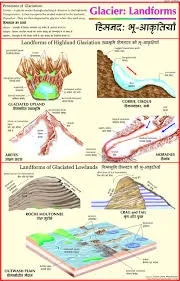
The “Glacier 2: Glacial Landforms (50x70cm)” chart is a mid-sized, laminated educational poster that visually explains a wide variety of glacial landforms produced by both the erosional and depositional activities of glaciers. This chart is commonly used in geography classrooms and environmental science lectures to reinforce key concepts related to glacial geomorphology.
Key Features
The chart is colorfully illustrated and easy to read, often with English and Hindi labeling, and is laminated with plastic rollers for convenient hanging and durability.
It provides graphic representations and definitions of multiple glacial landforms, such as cirques, arêtes, horns, U-shaped valleys, fjords, hanging valleys, moraines, drumlins, eskers, kames, kettle holes, outwash plains, and erratics.
The poster depicts the processes of glacial erosion, transportation, and deposition and shows how glaciers sculpt landscapes both in mountainous and lowland regions.
Some charts offer engaging discussion prompts and activities to encourage analytical thinking about the influence of glaciers on the Earth’s surface.
Educational Use
The 50x70cm format is suitable for group teaching, display in classrooms, or as a handy revision tool for geography learners.
Designed for easy integration with earth science and geography curricula, supporting the study of geomorphology, environmental change, and past climate cycles.
Charts are durable and visually appealing, making them useful for schools, colleges, and even home study settings.
Specifications
| Model No. | N-C037 |
|---|


